
Orbio Earth
Satellite-powered methane emissions tracking for oil & gas and finance.
Orbio Earth fills a critical gap in methane monitoring by making satellite-derived emissions data actionable. Its strength lies in automated pipeline and multi-satellite fusion, but pricing is enterprise-only, and detection limits miss smaller leaks. Ideal for large operators and regulators, not for casual use. For smaller operators, consider GHGSat or Kayrros for more flexible tiers.
Verified 14d ago · liveness 64/100 · cite: rightaichoice.com/tools/orbio-earth
- Oil and gas operators needing methane detection for regulatory compliance (OGMP 2.0, EU MRV)
- Environmental regulators monitoring regional emission trends
- ESG investors requiring verified methane data for portfolio risk assessment
- Researchers studying methane sources and trends at global scale
- Personal use or hobbyists due to enterprise-focused pricing
- Real-time monitoring: satellite revisits introduce daily+ delays
- Small-scale leak detection: best for large plumes >100 kg/hr
We scan live Reddit threads, YouTube comments, X posts, G2 reviews and other communities — and hand you an honest verdict in under a minute.
- Honest verdict, not marketing
- Real pros & cons from real users
- Attributed quotes with receipts
3 free scans · no card needed
Skip Orbio Earth if you are a small operator, independent researcher, or hobbyist needing affordable access to methane data, real-time sub-hourly monitoring, or detection of small leaks below 100 kg/hr—you'll hit cost and detection barriers.
Enterprise-only pricing likely carries a high annual contract amount, with no public tier to scale down for smaller budgets.
Orbio's enterprise-only pricing fits large operators and regulatory bodies with substantial budgets. For smaller players, GHGSat or Kayrros offer more flexible tiers, though they may lack Orbio's automated compliance reporting.
In short
Orbio Earth — Satellite-powered methane emissions tracking for oil & gas and finance. Best for Oil and gas operators needing methane detection for regulatory compliance (OGMP 2.0, EU MRV), Environmental regulators monitoring regional emission trends, ESG investors requiring verified methane data for portfolio risk assessment. Paid pricing.
What people actually say about Orbio Earth — is it worth it?
We scanned public community sources for Orbio Earth on Aug 12, 2026 and could not establish that the discussion we found is about this tool rather than something else sharing its name. Our own analysis of that scan says the posts were off-subject. Rather than publish a sentiment score built on the wrong subject, we publish nothing here and re-run the scan.
Viability Score
How well maintained and how widely used is Orbio Earth? Built from what the vendor actually publishes (docs, changelog, tutorials, integrations, pricing), whether the site is live, and how much real users discuss it. How we calculate this
Last calculated: September 2026
How we score →Key Features
- Multi-satellite fusion (Sentinel-2, Sentinel-5P, and others)
- AI-based plume detection
- Automatic emission quantification (kg/hr)
- Source attribution to facilities and regions
- Interactive map with heatmaps and event markers
- Customizable alerts for large releases
- Time-series analysis and trend charts
- Daily satellite imagery processing updates
- Exportable reports (PDF, CSV) for compliance
- API for integrating methane data
- Historical archive for baseline comparisons
- Web dashboard—no satellite expertise needed
- Real-time monitoring (as satellite data allows)
- Root cause analysis
About Orbio Earth
Orbio Earth is a satellite-powered platform that detects, quantifies, and visualizes methane emissions globally. Using data from multiple satellite constellations (including Sentinel-2, Sentinel-5P, and others), Orbio applies AI models to identify methane plumes, estimate emission rates, and attribute sources to specific facilities or regions. The platform serves oil & gas operators, environmental regulators, investors, and researchers who need transparent, verifiable methane data for emissions reporting, mitigation, and compliance. Users access Orbio via a web dashboard to explore methane hotspots, set up monitoring alerts, and download reports. The system processes satellite imagery daily, flagging large emission events and providing time-series analysis. What sets Orbio apart is its combination of multi-satellite fusion (using both point-source and area-flux sensors), automated plume detection, and a focus on making methane data accessible without requiring satellite expertise. The platform aims to bridge the gap between raw satellite data and actionable business intelligence, helping companies meet methane reduction targets (e.g., OGMP 2.0, EU MRV) and enabling stakeholders to hold emitters accountable. Orbio’s differentiator is its algorithm-to-insight pipeline, which reduces false positives and provides emission quantification in standard units (kg/hr). Compared to alternatives like GHGSat or Kayrros, Orbio emphasizes automated monitoring with real-time capabilities and direct integration into compliance workflows, though pricing is enterprise-only and detection limits are optimized for large plumes.
Behind the Verdict
Orbio Earth is a specialized tool for a serious problem: methane emissions are a potent greenhouse gas, and until recently, detecting them at scale was expensive and slow. Orbio's approach uses multiple satellite constellations and AI to automate plume detection and quantification, which is a big step up from manual analysis of raw satellite data. The automated pipeline is a real advantage—it reduces false positives and gives you emission rates in kg/hr, which are directly usable for reporting. Where Orbio shines is in large-scale monitoring: if you're an oil & gas operator with assets spread across regions, or a regulator watching for super-emitters, the platform's ability to process daily imagery and flag events is invaluable. The compliance angle is also strong—being able to generate OGMP 2.0 or EU MRV reports from the data saves time and adds credibility. But there are real constraints. The pricing is enterprise-only, which puts it out of reach for small operators or independent researchers. The detection threshold is optimized for large plumes (roughly 100-500 kg/hr), so smaller, chronic leaks may go unnoticed. Satellite revisit times mean you're not getting real-time data—events are detected days after they occur, which is fine for compliance but not for immediate response. And if you're a casual user or hobbyist, this is simply not the tool for you. Compared to alternatives like GHGSat or Kayrros, Orbio leans into automation and compliance integration. If you need a turnkey solution with less manual work, Orbio is compelling. But if you're looking for more flexible pricing or need to detect smaller emissions, you might need to look elsewhere. For large operators and regulators, Orbio Earth is a strong choice; for everyone else, it's likely overkill.
Researching Orbio Earth? Get your full AI stack in 60 seconds.
Free, no signup — tell us your goal and get tools matched to your budget & existing stack.
Real-world workflow fit
Concrete scenarios for the personas Orbio Earth actually fits — and what changes day-one when you adopt it.
You need to monitor methane emissions across your asset portfolio and generate OGMP 2.0 reports.
Outcome: Within a day, you set up monitoring alerts for your facilities. Orbio's dashboard flags super-emitters and auto-generates compliance reports, cutting your reporting time by 80%.
You need to assess methane risks for your portfolio companies before making investment decisions.
Outcome: You use Orbio's data to benchmark companies against peers, identify high emitters, and include quantitative methane metrics in your ESG reports, strengthening your risk assessment.
You want to monitor regional emission trends and identify hotspots for enforcement.
Outcome: You deploy Orbio to get a regional view of methane sources, prioritize inspections based on data, and track trends over time, improving regulatory oversight.
Use Cases
- Monitor methane emissions across your entire oil and gas asset portfolio using satellite data.
- Identify and quantify super-emitter events for rapid mitigation and reporting.
- Generate compliance reports aligned with OGMP 2.0 and EU Methane Regulation.
- Benchmark a company's methane performance against industry peers using satellite-derived data.
- Provide independent, transparent methane data for ESG disclosure and investor requests.
Limitations
- No public pricing tiers beyond Enterprise; likely high cost.
- Satellite revisit times of 1-12 days mean event detection is not real-time.
- Detection threshold around 100-500 kg/hr for point sources, so small leaks may be missed.
- API access is restricted to enterprise clients.
as of 2026-09-01
Verification history
We have re-verified Orbio Earth 7 times since . Each pass re-reads the vendor's own pages and re-checks every listed field against that evidence; passes where nothing had changed are marked as such.
- — re-checked, vendor evidence unchanged
- — re-checked, vendor evidence unchanged
- — re-checked, vendor evidence unchanged
- — re-checked, vendor evidence unchanged
- — re-checked, vendor evidence unchanged
- — re-verified summary, description, our verdict, our analysis, pricing model, pricing tiers, features, integrations, who it suits, who should skip it
Showing the 6 most recent of 7 verification passes.
Free to cite with attribution — this page re-verifies continuously.
12-month cost
Project the real annual outlay, including the implied monthly cost when only an annual tier is published.
Vendor list price only. Add-on usage, seat overages, and contract minimums are surfaced under Hidden costs & gotchas.
Plans compared
For each published Orbio Earth tier: who it actually fits, and what it adds vs. the previous tier. Cross-reference the cost calculator above for projected annual outlay.
Enterprise
Custom
Ideal for
Large oil & gas companies, regulators, and institutional investors with significant budgets and need for global methane monitoring and compliance reporting.
What this tier adds
Starting tier with full access to plume detection, quantification, attribution, alerts, and API. Pricing is custom, tailored to enterprise needs.
Where the pricing makes sense
The company stage and team size where Orbio Earth's pricing actually pencils out — and where peers do it cheaper.
Orbio's enterprise-only pricing fits large operators and regulatory bodies with substantial budgets. For smaller players, GHGSat or Kayrros offer more flexible tiers, though they may lack Orbio's automated compliance reporting.
Setup time & first value
How long it actually takes to get something useful out of Orbio Earth — broken out by persona, not the marketing-page minute.
For most users (operators, regulators, ESG analysts), the web dashboard is accessible within minutes of account provisioning. Basic exploration starts immediately; setting up custom alerts and report templates takes a few hours to a day. API integration may require a few days depending on your data pipeline.
Integrations
Resources & Guides
Tutorials & Learning
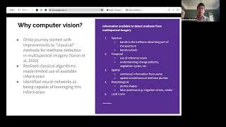
YouTube returned 6 videos for “Orbio Earth”, and we withheld 5: 5 did not mention Orbio Earth. Showing the 1 we can prove is about Orbio Earth.
Official links
Tools that pair well with Orbio Earth
Common stack mates teams adopt alongside Orbio Earth, with the specific reason each pairing earns its keep.

Mineral (Alphabet X)
Alphabet X's per-plant AI crop intelligence, now powering Driscoll's and John Deere

Dcipher Insight Booster
Automate enterprise-scale research, analysis, and report generation with agentic AI workflows.

Superintelligent
Enterprise AI planning platform that combines interview agents with proprietary market data to build data-driven AI roadmaps.
Featured Head-to-Head Comparisons
Orbio Earth vs Screenplayiq
These tools serve entirely different markets, so a direct comparison is misguided. Orbio Earth is an enterprise satellite methane monitoring platform for oil & gas and environmental compliance, while ScreenplayIQ is an AI screenwriting tool for film industry professionals predicting box office returns. Choose based on your domain: methane emissions tracking (Orbio) or screenplay marketability analysis (ScreenplayIQ). There is no overlap.
Orbio Earth vs Nectar Energy
Choose Nectar Energy if you're a facility manager or property owner seeking automated HVAC/lighting optimization and ESG reporting for commercial buildings. Choose Orbio Earth if you are an oil & gas operator, regulator, or investor needing satellite-based methane detection and quantification for compliance or ESG.
Orbio Earth vs Geologicai
GeologicAI and Orbio Earth serve completely different industries and needs. If you're in critical minerals mining and need fast, integrated core scanning to accelerate project timelines, GeologicAI is the clear choice with its recent LIBS sensor addition. If you're in oil & gas or environmental monitoring and need satellite-based methane tracking for compliance or ESG reporting, Orbio Earth is the go-to platform despite its enterprise price point.
Alternatives to Orbio Earth
View all
Mineral (Alphabet X)
Alphabet X's per-plant AI crop intelligence, now powering Driscoll's and John Deere

Dcipher Insight Booster
Automate enterprise-scale research, analysis, and report generation with agentic AI workflows.

Superintelligent
Enterprise AI planning platform that combines interview agents with proprietary market data to build data-driven AI roadmaps.
Frequently Asked Questions
Best-of guides
Used Orbio Earth? Help shape our editorial sentiment research.